Ray Wilson’s Summit Journey

September 14, 2022
I had been thinking about climbing Mt Katahdin in Maine for several years. Mind you, I am not a climber or serious hiker for that matter. But several things came together to say if I am going to attempt it, this is the year to try. At my annual physical with my doctor in March, he asked if and how I was planning to keep fit. And he said perhaps you should set a goal of some sort, and I blurted out, ”I am thinking about climbing Mt Katahdin in Maine.” While his nurse was giving me a further test, he went to his computer and Googled Mt Katahdin, came back into the exam room, and said that climbing to 5000 feet with a rise of 4000 feet would be a worthy goal.
Another thing that influenced the decision was that my 80th birthday was coming up in late August, and I figured if I would ever make it to the top, it needed to be sooner rather than later.
And I made the mistake of telling a number of my friends that I was going to try to climb the mountain. So I was kind of trapped. Along the way, I got some confirmation that my 22-year-old granddaughter, Cordelia, and her father, Fred, would consider going with me.
So about two months before the approximate time we would climb, I began doing about 15 minutes a day of leg strengthening. I did one set of 15 step-ups, heel downs, lunges to the front, lunges to the side, jump squats, single-leg RDLs, calf raises, and a few other odd moves without names. I also went for nearly daily fast walks of a mile or two and rode my bike 50 or so miles a week. Toward the end of the time, I did a few longer walks with a small backpack with a gallon jug of water in it.
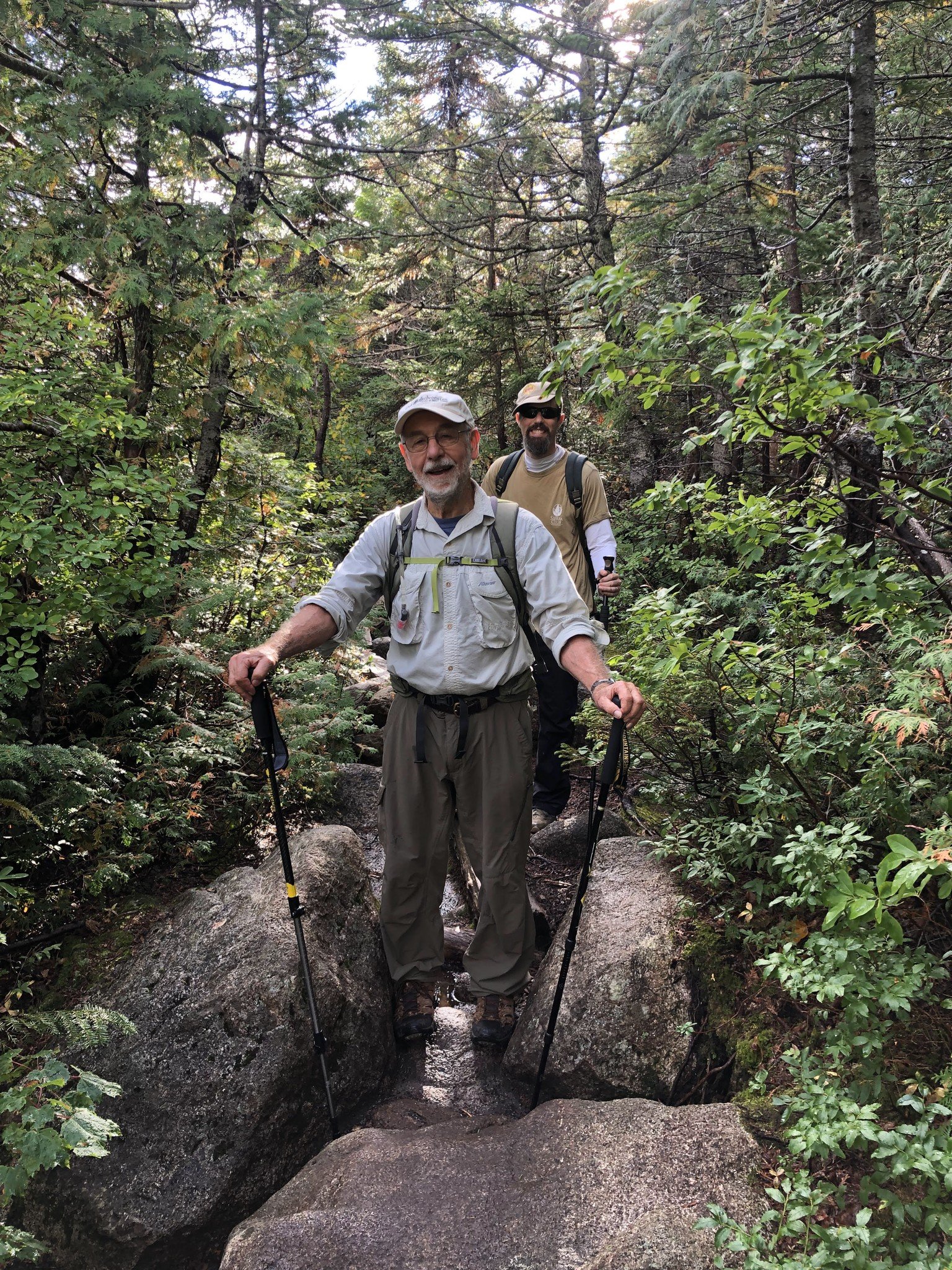
Tumbledown
My wife Cindy and I went to Maine just before my birthday in late August, and Cordelia took me on a few training climbs. The first one was to climb Mt Battie in Camden, ME. We chose the steepest route to the 780-foot summit. The second training hike was more substantial. We climbed Tumbledown Mountain. We took the Loop trail of about 5.3 miles and 2000 feet of elevation gain. There is some serious climbing and lots of rocks to navigate on this hike. I learned one important lesson on this climb. Don’t wear blue jeans to climb mountains. When they get damp, they don’t slide on your legs, and when you try to lift your leg to step up, you literally have to pull up your pant leg to make the step.
So when we got home, we made a quick trip to the thrift store to purchase a pair of actual hiking pants. We found a nice pair for 10 bucks and almost the right size, too.
As time drew near in late August, Cordy did the work of helping us figure out what was the best (easiest?) route to take, where we should camp near the trailhead we wanted, and how to make that all happen. I will refer anyone interested in the details of getting reservations at a campsite, a parking spot, etc., to the many helpful suggestions online (this FB group in particular) about Baxter State Park and climbing Mt Katahdin. But don’t underestimate the challenge of getting the date and location you desire.
Of course, we all want to camp and climb in the best weather possible, but unfortunately, that is not possible to predict several weeks and even months out as you are making a reservation. So go with what you got.
Roaring Brook Camp Site
We did get a reservation for a tent site at Roaring Brook campgrounds on September 13 and arrived late afternoon, knowing that we needed to get our tent set up fairly quickly because rain was predicted at any time. As it turned out, we even had a little time to cook a simple meal before dark and heading to bed. But then it did rain. It started out sounding like popcorn was popping as each raindrop came through the trees and hit the tent. And finally, it turned into a total roar of popping corn as the rain poured all night.
Our goal was to wake up at 5:15, cook some oatmeal, and be on the trail at 6. Well, it was still raining at that time, and we deferred trying to cook in the rain. But an hour later, the rain had pretty much slowed down so that we could get something in our tummies. We signed in at the ranger station at 7:00 a.m.
We started with raingear on and each carrying enough water, sandwiches, snack bars, and warm clothing to get us to the top and back. We chose to do the Chimney Pond and Saddle trails to the top. They are not the shortest, but some say they are the easiest.
I can confirm that none of the trails was easy for me. The closer I got to the end of the 3.3-mile Chimney Pond trail, the harder it got for me. As we were climbing, we encountered other small groups of climbers. The faster ones passed through, and sometimes we would catch up and pass by them.
As we were nearing the end of the Chimney Pond trail, there was a nice ranger standing by the trail welcoming us and asking about our intentions to hike further. When we let him know that we intended to climb to the summit, he told us what to expect weather-wise up on the top of the saddle and beyond – that it would be cold, windy, and probably raining. And that tomorrow would be much worse with a cold front moving in.
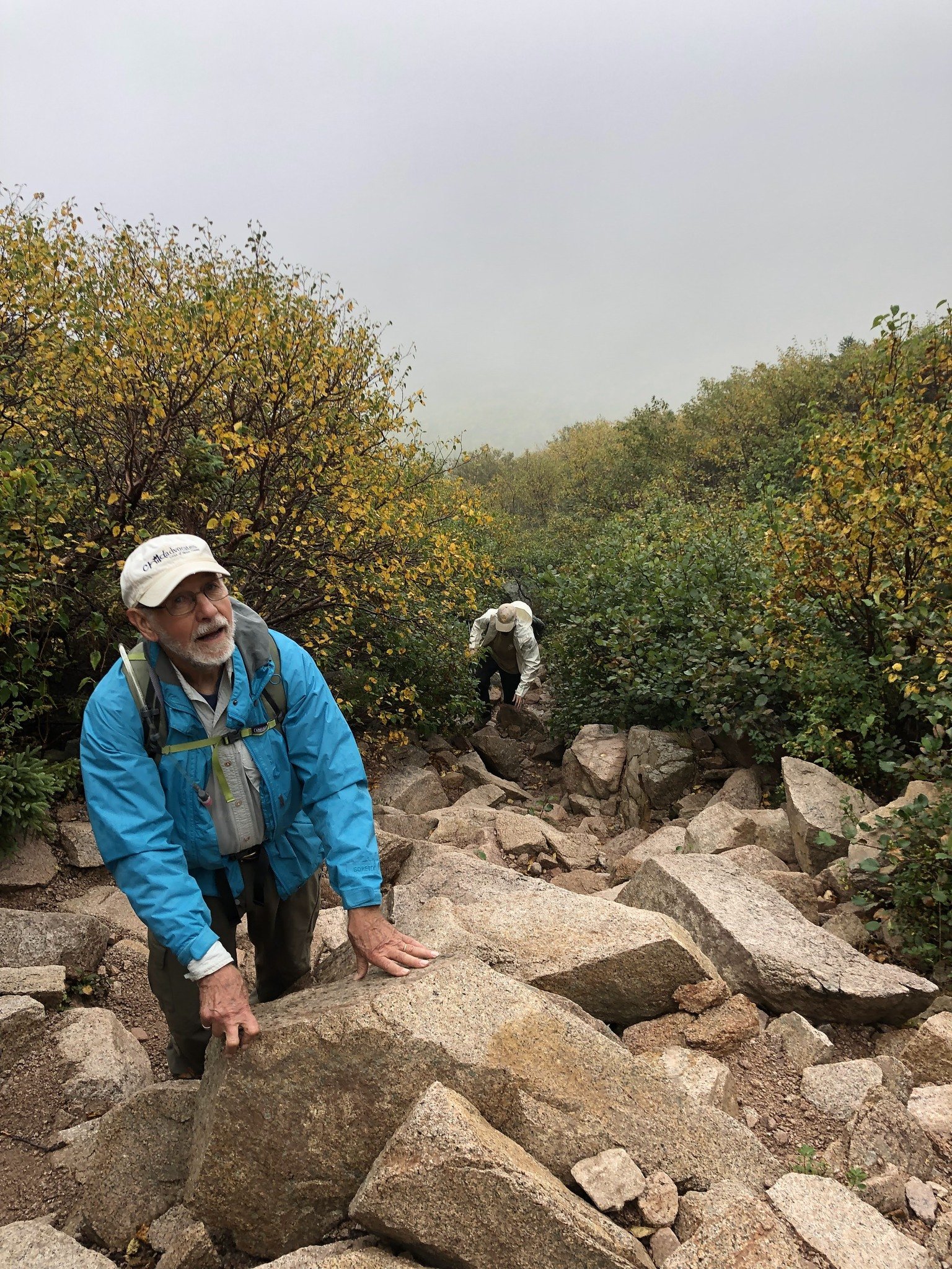
So we set off on the 2.2-mile Saddle Trail portion of the journey. This was harder! At this point, I should mention that I abandoned my trekking poles and handed them to my Sherpa granddaughter to carry in her deeper backpack. Because in this portion of the trail, it is hands grabbing onto rocks to get a little further up the mountain. Once, it was Cordy pulling and Fred pushing to get me up and over one rock ledge.

At one point, I was negotiating climbing over a large rock and felt I was over it. I began to straighten up and unfortunately didn’t realize that my center of gravity had changed with a 15-pound pack on my back. I fell backward. Fortunately, Fred kind of caught me as we both tumbled backward, and neither of us was hurt.
As we got near the top of the saddle, people were coming down, and they confirmed what the ranger predicted. In fact, it started raining just then, and so we hastily put on all the warm clothing we had packed and our rain gear. When we got to the point where the wind began howling, we had to decide whether to go on or turn back. Fred asked me if I felt stable enough in the wind. I said, “ Let’s get a little further on the path to see what it actually looks and feels like.”
Dressing for the Top
We had earlier decided that our turnaround time would be 1 p.m. It was about noon at this point, and we had a mile to go to reach the actual summit. We all felt warm and capable of going on, and so we set off. It actually seemed a lot further and was more climbing than I anticipated. But with Cordy’s encouragement, we trudged on. Finally, in the distance, we saw what appeared to be a whole bunch of people dancing around the Mt Katahdin sign. We thought, how can that be? All the people climbing with us had turned around when they got to the top of the saddle. Maybe it was a mirage. But no, it wasn’t. It was a group of 8 -10 young 20-something kids who were just finishing their 5 or 6 months-long hike of the Appalachian Trail. They were taking pictures with the sign–all with shorts on, no jackets and having a great time taking each other’s pictures.

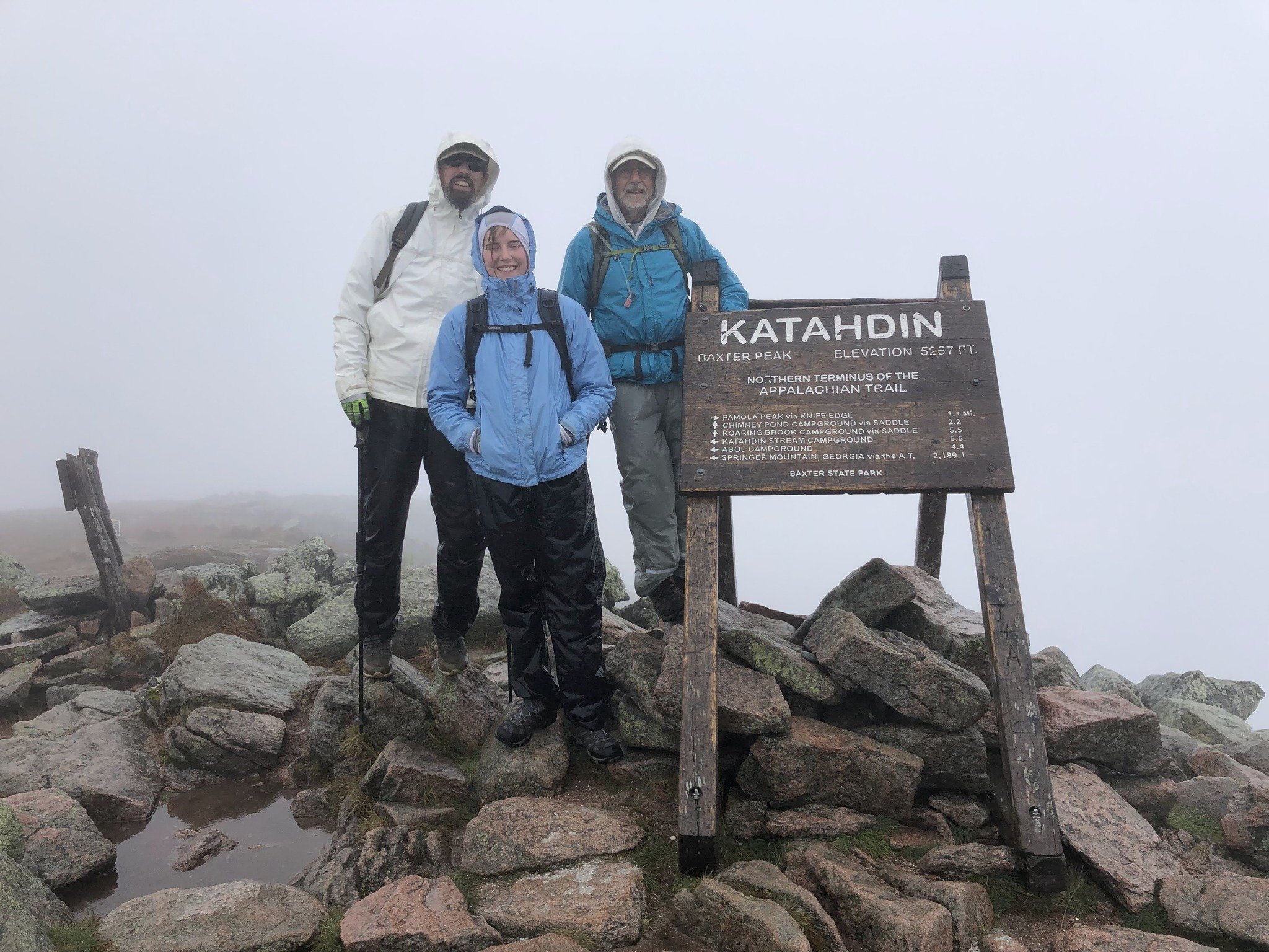
Fred, Cordelia, and Ray
Meanwhile, we were standing there watching, totally soaked to the skin from the driving rain and starting to get cold. Shortly all but one of the kids took off down the Saddle Trail. The woman who kindly stayed took a group picture of us standing by the Mt Katahdin sign.
And then I saw a scene that will stick in my mind forever. This young woman in a tee shirt and shorts and sneakers and a full pack glided off across the rocks like a nymph into the clouds. She was just bounding from rock to rock. And I am thinking—oh, to be 20 years old and strong and healthy!
And then I came back to reality, AND it was now 12:45 p.m.—almost turnaround time. On the way back to the saddle, to let you know how strong the wind was, I bent over to examine one of the pink rocks on the path as we left the sign. As I did so and began to straighten up, the wind knocked me backward onto my butt.
Going down the mountain for me was harder than going up. However, butt-sliding down some boulders was fun. By the time we got back to the Chimney Pond trailhead, it had stopped raining, and we could get out of our rain gear and finally eat our sandwich lunches. I was relieved to find one dry pair of socks in my backpack, which, it turned out, helped save my toes on the steep downslopes.
Typical Path
The 3.3-mile hike back to the Roaring Brook campground seemed to go on forever. It was then that I realized that every step required numerous decisions. Do I step on or over the rock? Will the rock be slippery? Do I go around the rock, and which way? Where should I land my hiking poles? So mental tiredness was every bit as prominent as physical fatigue.
We signed the ranger log sheet at 6:45 p.m.—almost 12 hours for the round trip. Under the circumstances a respectable time, I think!
A few final reflections
I started out carrying 2 ½ liters of water in an Osprey water bladder. It sure beat dealing with water bottles. 1 ½ liters would have been plenty for this hike.
My 5 ½-year-old ConforMIS replacement knee joints performed beautifully – no pain whatsoever.
I hiked with Mountainsmith trekking poles. One was the Trekker FX with clamping adjustment levers, and the other with twist–lock adjustment. Both performed properly. I rarely put my hands in the wrist straps for fear that if I fell, I would not get my hands free in time to break my fall.
I found it to be wonderful that three generations of the family could do this together. By the way, Cordelia did this same climb when she was 10 years old. I waited 80 years.
- Ray Wilson